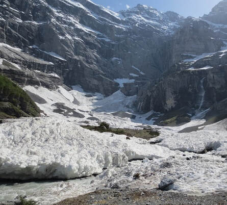
 An easy walk to a real glacier is possible. Search on your tube for Kilchbalm and you will find someone’s vid of this magical place that no one seems to know about and it’s not far from the apartment. Kilchbalm (Gimmelwald - Sefinental - Kilchbalm) Glasier Time one-way: 1 1/4 hours Distance one-way: 2 3/4 miles (4 1/2km) Lowest point: 4134 ft (1260m) Highest point: 5046 ft (1 538m) You can get cable car from Schilthorn Bahn up to Gimmelwald. (Bus from outside Eyhus along to Schilthorn Bahn in the direction of Stechelberg) The gradient is not very steep, and you can walk to the very end of the Sefinental valley, where only freezing-cold streams flowing from the snow and ice ( real glacier) and the heartiest vegetation exist. There is a small hut along the way , but it is lovely to have a picnic at the end. The scenery is beautiful in both directions. Since there is only one road in Gimmelwald, it is difficult to get lost. Where the road loops back on itself, by the fire-house, is a road leading into the Sefinental. From this point you can see all the way to the end of the valley and quickly realize that the end is not much higher than Gimmelwald. After walking downhill for 7 minutes you will come to a bridge that crosses a torrential waterfall that has gouged deep holes, through the years, in the side of the mountain. It now flows deep in the rock and splashes from pool to pool, plunging some 20 feet into a huge cavity beside this bridge to continue its way down to the valley floor. This waterfall is the same as "Sprutz" higher up and is called the "Schiltbach" which is the stream created by the runoff from the Schilthorn and the Schiltalp. After walking 8 minutes further you pass a firing range where locals come to practice, usually on weekends. A minute more and you come to the end of the road and the beginning of your ascent on a rocky trail. Here a signpost says that Kilchbalm, your destination, is 1 hour away. (It is also from this point that you can stay on the main road which leads to a trail that descends to Stechelberg or back up to Gimmelwald.) As you leave the main road and continue straight ahead through the gate, the mighty snow covered ridge on your left, called the Tschingelgrat, grabs your attention. Watch this ridge for avalanches which occur frequently and at any time. Soon you're walking through a dense forest with the Sefinen Lutschine swirling and splashing on your left side, where it will be all the way to the end of the valley. 15 minutes later, after passing some old sheds and massive rock overhangs, you come upon an old storage building from 1812 raised up on rocks. Next to it is a cable attached to the cliff above used for transporting logs. Shortly the path becomes very narrow and rocky. In 7 minutes you pass through the second gate and in a few minutes more you'll cross the first bridge. At the third gate, 7 minutes later, the path splits. (Note: this area has been known to be full of snow well into the early summer months, depending on the previous winter you should exercise extreme caution and perhaps turn back here if it is too dangerous ). Assuming the way is dry, you will take the lower path, to the left (If you were to continue on the path to the right, you would pass a tiny waterfall, perfect for splashing under on a hot day, and eventually arrive at Boganggen and Rotstockhutte 600 meters higher up the mountain). Just behind the trees, around the bend is a grassy meadow and an alp hut. Occasionally cows are brought here for summer grazing. The farmer will stay here with his herd until it's time to move to better pastures. It is beside this hut where the Sefinen river, on the left is joined by the Sefibach, on the right, which comes down from the Sefinen alp. Following the path, close to the river, soon brings you to a second bridge. Before crossing the bridge, venture up to the waterfall created by the Sefibach but be careful of falling stones and branches. Once across the bridge you come to the steepest part of the trip. Here you witness the power of the Sefinen river. In spring and during heavy rainstorms this river is so swollen that it violently tears at the hillside bringing tons of rock and debris down with it. Once at the top you can rest on the last bench before reaching the end of the valley and the Kilchbalm. We think that Kilch is the word for goblet or cup and you will see how this valley looks like a deep cup. The towering cliffs make it a spectacular setting for a picnic without crowds and you will want to stay forever. |
Eyhus 5
Where dreams begin for outdoor adventures in the inspiring Jungfrau region Categories
All
Archives
July 2024
|
|
Eyhus 5,
3822 Lauterbrunnen, Schweiz Email: [email protected] About Us: We love the Jungfrau Region and enjoy helping guests to plan and discover the beauty here for themselves. Summer, Winter, Spring and Autumn each have their opportunities to give inspiration in this amazing Playground. |
|

 RSS Feed

